
“What is Boyle Heights? And what makes it tick? It is not a “typical” American community, but it could only happen in America…”
Fortnight: California’s Own Newsmagazine (1954)
 A neighborhood is made up of people and places. It is defined through the experiences of those who consider it home. And it holds their hopes for the future and their memories of the past.
Boyle Heights is a Los Angeles neighborhood, located just east of downtown between the Los Angeles River and the city boundary. It is one of the city’s earliest neighborhoods, and—like all communities—it has changed in many ways over the past century.
Boyle Heights is a Los Angeles intersection, a place of infinite possibilities where the paths of different people meet or cross. Boyle Heights has been home to people who have come to Los Angeles from different cities, states, and countries, who have different beliefs and traditions, and who speak different languages.
Through the stories of past and present neighborhood residents, this exhibition explores how the experiences and memories of many generations of Angelenos intersect in this powerful place.
The exhibition features materials—photographs, artifacts, artwork, moving images, and oral histories—collected over the past two years in community forums, collection days, and through oral history interviews. These materials are organized to highlight selected events, themes, and places that demonstrate how people’s lives intersect in the neighborhood.
 Avenida Cesar E. Chavez, formerly Brooklyn Avenue, is the backbone of the exhibition, weaving together all of the different stories presented. This street is a local landmark; a vital artery connecting Boyle Heights to its past and to the greater region.
Since the 1930s, when it was the center of L.A.’s Jewish community, the street has been a vibrant hub of social and commercial life for all local residents. Stretching two miles through the neighborhood, this street links Boyle Heights to the site of Los Angeles’ original pueblo and to the greater East L.A. area. In 1995, Brooklyn Avenue was renamed Avenida Cesar E. Chavez in honor of the late Chicano civil rights leader.
A survey of photographs showing the entire length of this street in Boyle Heights runs through the gallery. Certain intersections are highlighted in order to explore key themes, events, and neighborhood sites. Throughout the entire exhibition, past and present stories, images, and artifacts are juxtaposed to demonstrate how the lives of many different people have directly and indirectly intersected in the neighborhood.
Key Exhibition Themes
- Boyle Heights: A Los Angeles Intersection
“This introductory section provides an overview of the history of the neighborhood as well as the people who have, at different times, made a home for themselves in Boyle Heights.
- East of the L.A. River: Contested Space
Bound by the L.A. River and divided by a concrete tangle of freeways, Boyle Heights is physically segregated from downtown Los Angeles. The area immediately east of the L.A. River is commonly referred to as “the flats.” Mission Road, which runs through this section of the neighborhood, is dominated by rail yards, warehouses, factories, and auto salvage yards. Housing policies and freeway construction have kept this area transitional, as it is continually re-imagined and re-shaped to suit changing needs-not always shared by local residents.
- “East Side Greeting, We Welcome All”: Early Community Building; Enduring Institutions
Many early organizations and residences were established along Boyle Avenue. “East Side Greeting, We Welcome All” was the banner that was displayed in Boyle Heights on the first day of service of the Los Angeles Cable Railway into East L.A. in 1889. This public transportation line was critical in the development of Boyle Heights as a viable residential settlement. The International Institute of Los Angeles, established in 1914 in Boyle Heights to assist new immigrants adapting to life in Los Angeles, has been located on Boyle Avenue since the 1920s.
- Faith in a Community: Religion
The Breed Street Shul, once the largest Jewish synagogue in Los Angeles, is located just south of the corner of Breed Street and Cesar Chavez. Today, it is the site of multi-ethnic and multi-generational collaboration between the Jewish Historical Society of Southern California and current, primarily Latino, neighborhood residents. Together, they are working to restore the building and convert it into a community and cultural center. Many other houses of worship of various denominations continue to serve the diverse spiritual needs of local residents with services conducted in English, Spanish, Russian, Armenian, and Korean.
- “The Heart of the Eastside”: The Symbolic and Social Center of Neighborhood Life
Pulsating with a constant flow of pedestrian traffic, the corner of Cesar Chavez and Soto Street is a crossroads, the symbolic and social center of neighborhood life. This section of the exhibition highlights the social and cultural vitality of this particular intersection. It also explores a moment in time—World War II—that had a critical and lasting impact on neighborhood life.
- Growing Up on the Eastside: Youth/Growing Up
Following Mathews Street south from Cesar Chavez, it eventually intersects Fourth Street. At this corner is Theodore Roosevelt Senior High School, the only public high school in the neighborhood and an enduring symbol of neighborhood identity.
- “Land of a Thousand Dances”: Rhythms and Music of Neighborhood Life
In the past and present, a number of businesses serving the musical needs of the area have punctuated the street between Mott and Evergreen. These include stores selling musical instruments, records, as well as businesses that specialize in the apparel worn by Mexican traditional musicians. This section of the exhibition features a listening station where visitors can listen to music by eastside artists and audio excerpts of oral history interviews.
- The Power of Place
The exhibition concludes at “Cinco Puntos,” five points, a corner where several streets cross. One of these streets, Indiana, is the neighborhood’s eastern boundary as well as the dividing line between the City of Los Angeles and the unincorporated area of East Los Angeles.
- Community Center
Located within the gallery, this interactive area provides hands-on materials, writing, and storytelling activities.
- Animating the Landscape
Located outdoors in the Manabi and Sumi Hirasaki Family Garden of the Japanese American National Museum, this area features changing, seasonal installations representing different cultural traditions.
Banner image: Boyle Heights neighborhood sign, ca. 1990. Photograph by Yolanda Guerra.
Shades of L.A. Archives/Los Angeles Public Library (NRC.2002.46.1)
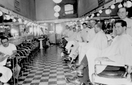
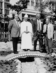
Photos: Leaders Barbershop, ca. 1945. Courtesy of Lucille Abrams (2001.210.2); Colonel Bud Weber, Reverend Alfred Tsuyuki, Principal Henry Ronquillo, and Paul Bannai at Japanese garden rededication, 1995. Photograph by Archie Miyatake. Courtesy of Bruce Kaji (NRC.2002.62.2)
About this Site
The content for this microsite was originally created in 2002 in conjunction with the exhibition and included many of the resources collected for the Boyle Heights Project. It was moved into this new microsite on janm.org in 2023. Some additional, newer content was added to supplement and update the original content.
“What is Boyle Heights? And what makes it tick? It is not a “typical” American community, but it could only happen in America…”
Fortnight: California’s Own Newsmagazine (1954)
A neighborhood is made up of people and places. It is defined through the experiences of those who consider it home. And it holds their hopes for the future and their memories of the past.
Boyle Heights is a Los Angeles neighborhood, located just east of downtown between the Los Angeles River and the city boundary. It is one of the city’s earliest neighborhoods, and—like all communities—it has changed in many ways over the past century.
Boyle Heights is a Los Angeles intersection, a place of infinite possibilities where the paths of different people meet or cross. Boyle Heights has been home to people who have come to Los Angeles from different cities, states, and countries, who have different beliefs and traditions, and who speak different languages.
Through the stories of past and present neighborhood residents, this exhibition explores how the experiences and memories of many generations of Angelenos intersect in this powerful place.
The exhibition features materials—photographs, artifacts, artwork, moving images, and oral histories—collected over the past two years in community forums, collection days, and through oral history interviews. These materials are organized to highlight selected events, themes, and places that demonstrate how people’s lives intersect in the neighborhood.
Avenida Cesar E. Chavez, formerly Brooklyn Avenue, is the backbone of the exhibition, weaving together all of the different stories presented. This street is a local landmark; a vital artery connecting Boyle Heights to its past and to the greater region.
Since the 1930s, when it was the center of L.A.’s Jewish community, the street has been a vibrant hub of social and commercial life for all local residents. Stretching two miles through the neighborhood, this street links Boyle Heights to the site of Los Angeles’ original pueblo and to the greater East L.A. area. In 1995, Brooklyn Avenue was renamed Avenida Cesar E. Chavez in honor of the late Chicano civil rights leader.
A survey of photographs showing the entire length of this street in Boyle Heights runs through the gallery. Certain intersections are highlighted in order to explore key themes, events, and neighborhood sites. Throughout the entire exhibition, past and present stories, images, and artifacts are juxtaposed to demonstrate how the lives of many different people have directly and indirectly intersected in the neighborhood.
Key Exhibition Themes
- Boyle Heights: A Los Angeles Intersection
“This introductory section provides an overview of the history of the neighborhood as well as the people who have, at different times, made a home for themselves in Boyle Heights.
- East of the L.A. River: Contested Space
Bound by the L.A. River and divided by a concrete tangle of freeways, Boyle Heights is physically segregated from downtown Los Angeles. The area immediately east of the L.A. River is commonly referred to as “the flats.” Mission Road, which runs through this section of the neighborhood, is dominated by rail yards, warehouses, factories, and auto salvage yards. Housing policies and freeway construction have kept this area transitional, as it is continually re-imagined and re-shaped to suit changing needs-not always shared by local residents.
- “East Side Greeting, We Welcome All”: Early Community Building; Enduring Institutions
Many early organizations and residences were established along Boyle Avenue. “East Side Greeting, We Welcome All” was the banner that was displayed in Boyle Heights on the first day of service of the Los Angeles Cable Railway into East L.A. in 1889. This public transportation line was critical in the development of Boyle Heights as a viable residential settlement. The International Institute of Los Angeles, established in 1914 in Boyle Heights to assist new immigrants adapting to life in Los Angeles, has been located on Boyle Avenue since the 1920s.
- Faith in a Community: Religion
The Breed Street Shul, once the largest Jewish synagogue in Los Angeles, is located just south of the corner of Breed Street and Cesar Chavez. Today, it is the site of multi-ethnic and multi-generational collaboration between the Jewish Historical Society of Southern California and current, primarily Latino, neighborhood residents. Together, they are working to restore the building and convert it into a community and cultural center. Many other houses of worship of various denominations continue to serve the diverse spiritual needs of local residents with services conducted in English, Spanish, Russian, Armenian, and Korean.
- “The Heart of the Eastside”: The Symbolic and Social Center of Neighborhood Life
Pulsating with a constant flow of pedestrian traffic, the corner of Cesar Chavez and Soto Street is a crossroads, the symbolic and social center of neighborhood life. This section of the exhibition highlights the social and cultural vitality of this particular intersection. It also explores a moment in time—World War II—that had a critical and lasting impact on neighborhood life.
- Growing Up on the Eastside: Youth/Growing Up
Following Mathews Street south from Cesar Chavez, it eventually intersects Fourth Street. At this corner is Theodore Roosevelt Senior High School, the only public high school in the neighborhood and an enduring symbol of neighborhood identity.
- “Land of a Thousand Dances”: Rhythms and Music of Neighborhood Life
In the past and present, a number of businesses serving the musical needs of the area have punctuated the street between Mott and Evergreen. These include stores selling musical instruments, records, as well as businesses that specialize in the apparel worn by Mexican traditional musicians. This section of the exhibition features a listening station where visitors can listen to music by eastside artists and audio excerpts of oral history interviews.
- The Power of Place
The exhibition concludes at “Cinco Puntos,” five points, a corner where several streets cross. One of these streets, Indiana, is the neighborhood’s eastern boundary as well as the dividing line between the City of Los Angeles and the unincorporated area of East Los Angeles.
- Community Center
Located within the gallery, this interactive area provides hands-on materials, writing, and storytelling activities.
- Animating the Landscape
Located outdoors in the Manabi and Sumi Hirasaki Family Garden of the Japanese American National Museum, this area features changing, seasonal installations representing different cultural traditions.
Banner image: Boyle Heights neighborhood sign, ca. 1990. Photograph by Yolanda Guerra.
Shades of L.A. Archives/Los Angeles Public Library (NRC.2002.46.1)
Photos: Leaders Barbershop, ca. 1945. Courtesy of Lucille Abrams (2001.210.2); Colonel Bud Weber, Reverend Alfred Tsuyuki, Principal Henry Ronquillo, and Paul Bannai at Japanese garden rededication, 1995. Photograph by Archie Miyatake. Courtesy of Bruce Kaji (NRC.2002.62.2)
About this Site
The content for this microsite was originally created in 2002 in conjunction with the exhibition and included many of the resources collected for the Boyle Heights Project. It was moved into this new microsite on janm.org in 2023. Some additional, newer content was added to supplement and update the original content.
This is a carousel. This section contains multiple slides with links to event related exhibitions. Use the left and right arrow buttons to navigate.